Hiking Lows Ridge – Written by Adirondack Avian Expedition Guide, Joan Collins
4.4 MILES ROUND TRIP 4-5 Hours.
Trailhead Location:
From the intersection of Route 30 and Route 28 in the Village of Long Lake, follow Route 30 toward Tupper Lake. Continue for Approx. 14-miles to Route 421 on the left. Turn down 421 and continue for 6.5 miles to the old railroad station on Horseshoe Lake. Cross the railroad tracks on a secondary road and continue for 0.9 miles to a gated road on the left, park here away from the gate.
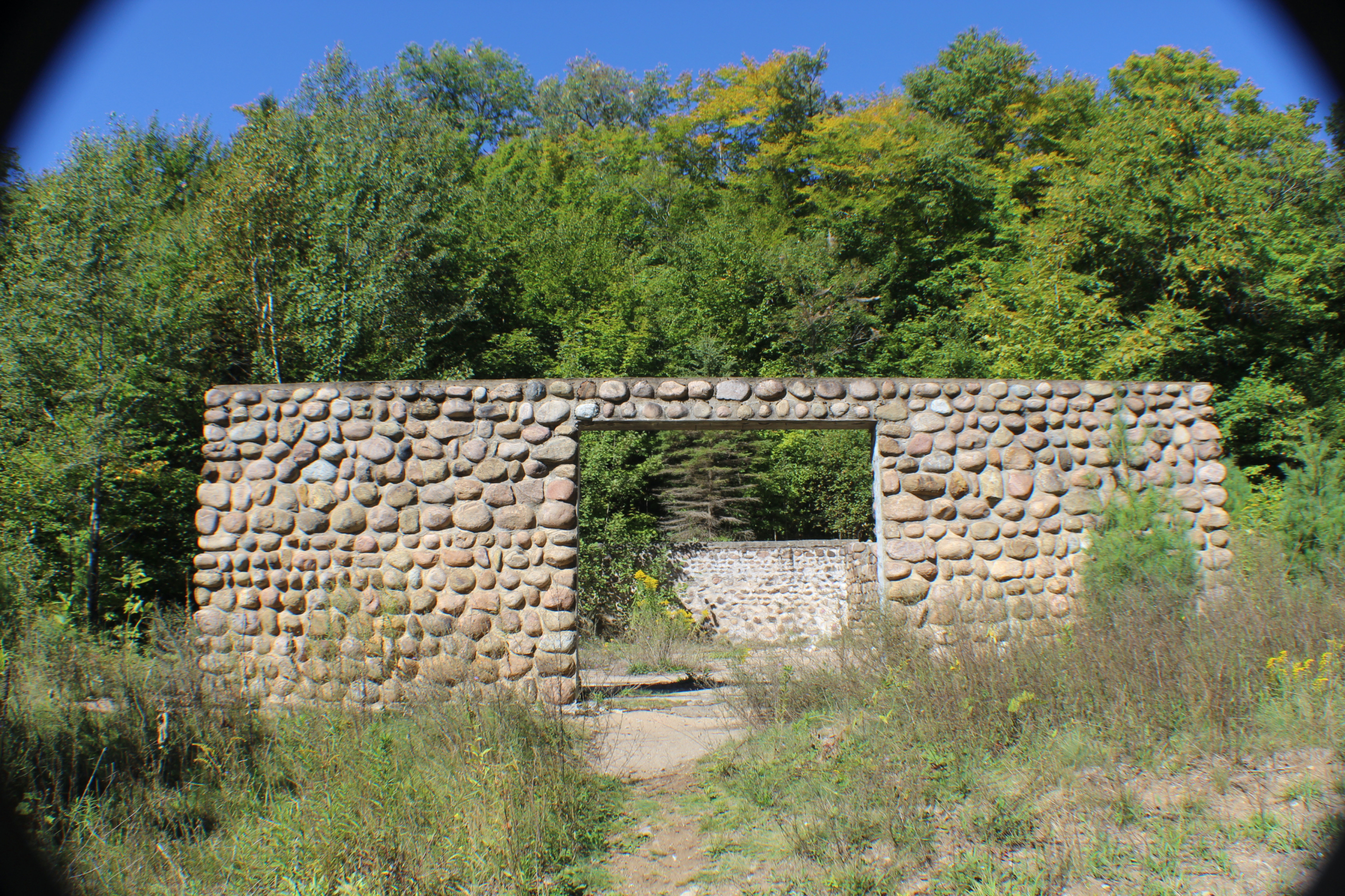
An easy walk on a dirt road that passes a bog and wetland. At Lows Lake Dam you’ll find the remains of the Augustus Low complex. Near the damn is a new trail climbing a small mountain that clims a small mountain overlooking Lows Lake and Hitchens Pond.
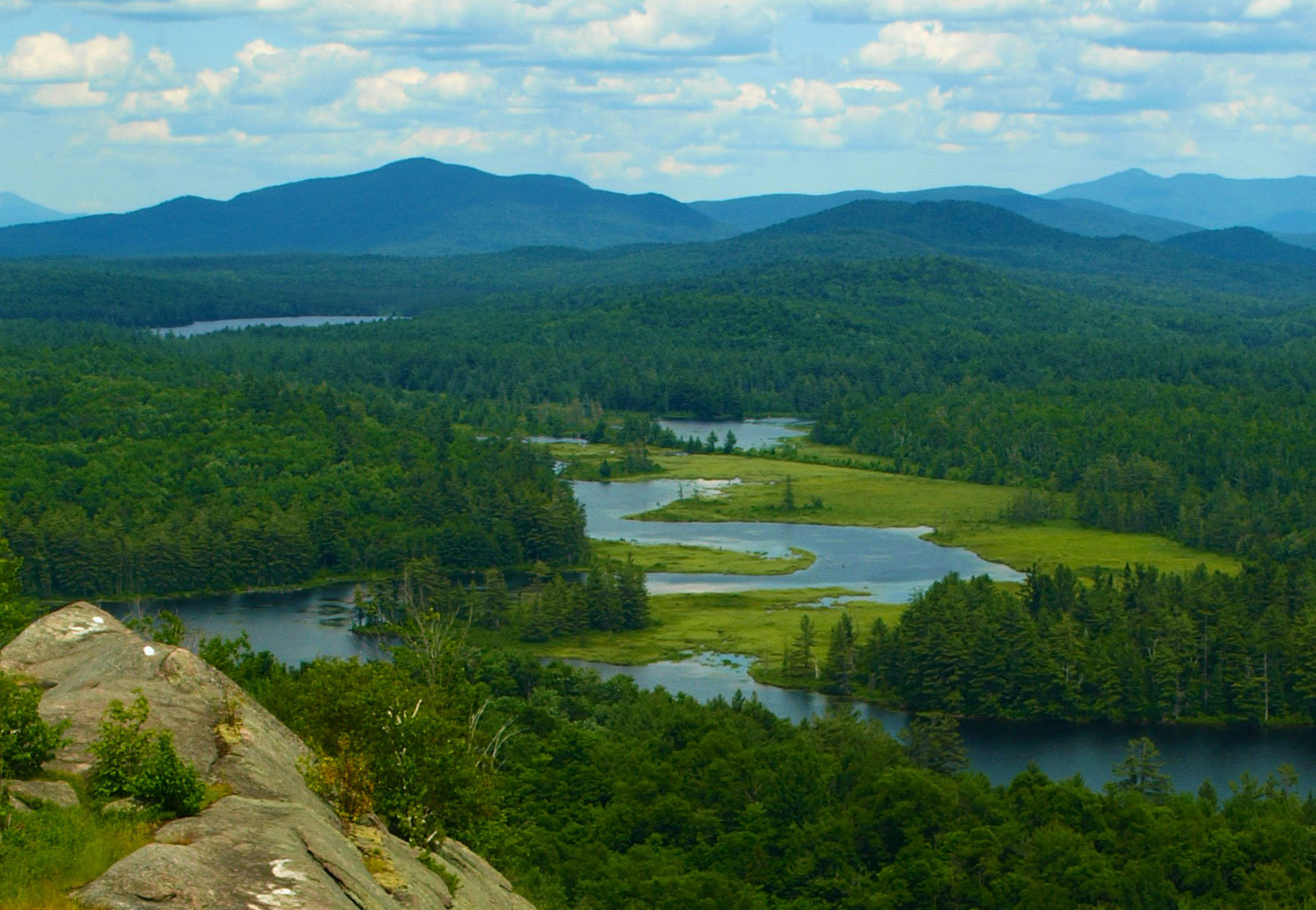
Common Loons nest on Hitchins Pond each year. Bald eagles and Great Blue Herons are also a common sight. The route is an old dirt road that passes through many lovely and varied habitat areas. After the 2.5 mile walk on level terrain to Hitchins Pond. Part two of the hike is a 1.5 mile round trip hike up Low’s Ridge featuring spectacular views of the Bog River Valley and High Peaks.
Great Leaf Peeping to be had.
NOTE: This is a flat, but long trip in a very isolated area. You must be in appropriate condition and you should bring energy food and lunch due to the length of the walk. Check in with trip organizers to order a lunch to be delivered trailside.
Paddlers Delight! A dual sport adventure from Low’s Lower Dam to Low’s Ridge
A surf and turf adventure is simple, first you paddle (surf) to a hike destination (turf) and then paddle back to your car. The Adirondacks are loaded with opportunities like these and the Long Lake Region does not fall short.
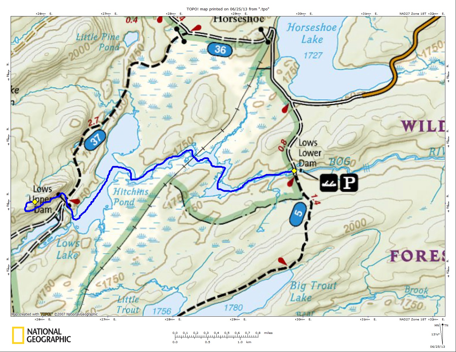
For this adventure you will have a short carry of only about 100 feet to the sand shore at Low’s Lower dam on Bog River. The launch itself is a scenic destination and a popular area for boating and fishing. The paddle starts out from the dam in a wide area with rock shores and calm waters. As you proceed to the west the passage gets a bit narrower and the scenery becomes even more inspiring. These narrows also bring shallow waters and submerged boulders that under lower water conditions might not clear the hull of your boat.
Moving along, the river widens a bit and you can explore the edges a bit easier as you make course to the makings of a river pond where all types of birds can be seen. Eagles have been seen in the region on several occasions and have great areas for nesting to the north. Great blue herons can be seen fishing along the shore in the shallows, while the unofficial bird of the Adirondacks – the black fly – buzzes your ears.
The rivers course will naturally swing you north through another narrow area that quickly enters another widening that travels west again and under the railroad tracks. The opposite side of the tracks brings you continually west parallel to a marsh area where red wing blackbirds can be seen by the dozens.
Its fun to skirt the marshland, as the waters depth is shallow enough to see the small fishes that live there and on occasion might stir up a passing otter. As you feed through the final narrows on this trip you will come to Hitchins Pond. Hitchins Pond is a north to south shaped pond. Heading north will dead-end you into Hitchins Bog, heading south will bring you to Low’s Upper Dam and the hike up Low’s Ridge, which is the turf portion of the day. Follow the natural course that leads you to a grassy area and the portage past the dam. Pull your boat ashore, change into your hiking boots and start your next leg.
As you hike up the old road you will pass by the remnants of old houses and structures to your right and during the right season wildflowers to fill your eyes. Cross the next dirt access road and follow the foot trail, a DEC trail signs marks the start.
The trail starts out climbing right off on a well traveled trail as it sweeps hard to the SW along the bottom of the ridge. After a small descent the trail meanders through the open hardwood forest and hooks around the backside of the ridges high point before climbing the west side to the open rock spine. Unbelievable views are had from this open rock and a bit of exploring along the ridge to the north will find you a plaque and an old carving on the rock dedicated to the Low’s, the original owners of this land.
To get back to your car you will need to read the above upside down and hope for the best, or, use the map and do a return journey downstream along the Bog River, the opposite direction for which you came. We recommend the latter.
Hike Distance:
1.25-miles, one way
Paddle Distance:
3-miles, one way
Directions to Launch:
From the intersection of Route 30 and Route 28 in the Village of Long Lake, follow Route 30 toward Tupper Lake. Continue for Approx. 14-miles to Route 421 on the left. Follow here for over 6-miles to the “Lows Dam road” on the left (State DEC sign). Drive this to the end for the launch.