Be prepared to immerse yourself in a beautiful new exploration.

The hikes in the Long Lake and Raquette Lake area boast mountains rich with history and beautiful vistas. Backpacking is a sport and hikers traveling in and around Long Lake make it a stop on their trek on the 133 Northville – Lake Placid Trail. It’s a popular stop to do laundry, send a postcard and gain more supplies for the rest of the journey.
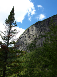
Explore the site of Noah John Rondeau’s hermitage in the wild Cold River Country or take an easy stroll to Buttermilk Falls. Owl’s Head Mountain in Long Lake or West Mountain in Raquette Lake offer more of a challenge and spectacular views. Biking is also a great way to see the Adirondacks. Check out our recreation map for biking info.


1. Frederica Mountain, Lake Lila (M) – 4.5 miles one way. From parking area, hike along Lake Lila Road for 3.2 miles or launch a boat and paddle to the trailhead. Frederica is 1.4 miles moderate hike up. Expect a daylong outing if you do this combo trip. Trailhead access located off of Sabattis Road.
2. Burn Road (m) – Access north shore of Little Tupper Lake. Trails branch off to interior waterways, including Rock Pond. 13.5 mile trail system utilizes logging roads. Trails are overgrown and beaver activity has caused washouts. Be prepared!
3. Stoney Pond Road Trailhead (M) 4 miles. This trail heads west along the south shore of Little Tupper Lake and ends at two separate camping areas.
4. Round Lake Trail/Hedgehog Pond Trail (E) – 2.1 one way. Trail starts at a yellow gate on Sabattis Circle Road north. Approx 0.4 miles north of intersection. This is a Conservation Easement. Once through the gate, you will see signs and red trail markers. Keep following the trail until you reach gate to Round Lake Wilderness Area. This trail will take you to a campsite on Round Lake, great for a picnic. This lake also offers 11 designated campsites along the shore.

(E) Located off of NYS Route 30 just north of Long Lake, NY.
Coney is 1.1 miles to the summit. Offers scenic views and is good for all skill levels. Heavily trafficked. Great for families or a quick hike to get the heart racing!

6. Goodman Mountain (E)
Goodman is 1.7 miles one way to summit. Great views. Pleasant combo of paved and dirt trail. Welcoming kiosks share the important story of Andrew Goodman, a young man with local ties to the region, a civil rights activist who was murdered in Mississippi in 1964.
Located north of Long Lake, NY off of NYS Route 30/Tupper Road

7. Lake Eaton Loop (M)
4.5 miles. Start in Lake Eaton Campground. Hike northeast, bearing right out of the campground. Following the snowmobile trail. Cross NYS Route 30/Tupper Road and circle back along the route to return to the start point at the campground. Ambitious hikers can opt for an alternate route and hike all the way around the backside of Lake Eaton and link up to the Owls Head Mountain Trail. Definitely adds mileage to the trip.

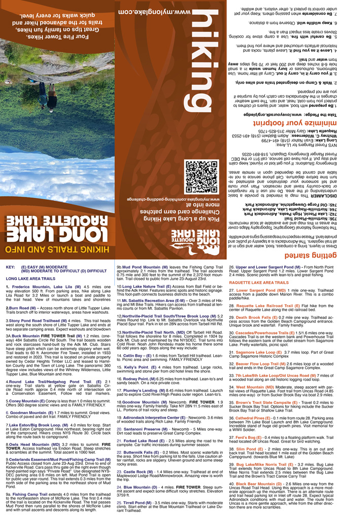
8. Owls Head Mountain (MD) 3.2 miles one way to summit. Fire Tower! Access via Endion Road 1.6 miles from NYS route 30. First two miles are fairly easy. The last mile is a bit steep with rocks to scramble up. Climb the fire tower to enjoy an expansive view of Long Lake.

9. Cedarlands Easement. (E) Public Access August 23rd – June 23rd. Access Mud Pond from the designated parking lot, boat carry trail now open. Cedarlands is located by traveling to the end of Kickerville Road in Long Lake. Drive down dirt access road beyond the stone gatehouse. It says private property, but it is open to the public. Travel down the dirt road. There is a designated parking area 0.6 miles from the trailhead on the left. network of trails include: Mud Pond/OA Mountain, McRorie Lake Trail, Mud Pond Trail. Hiking biking, paddling, fishing, x-c skiing permitted when easement is open to the public.
Located at the end of Kickerville Road, Long Lake, NY

10. The Long Lake Nature Trail connects the uptown area of Long Lake connecting the business district, Hoss’s, Custards, Diner to the Ball Field. It’s a short path around Jennings Park Pond leading to the Adirondack Hotel, Helms Aero Service and the Long Lake Town Beach. It’s a serene place to walk the dogs, take a jog and avoid the big hill in the middle of town. Over the years deer, frogs and even a moose have been spotted along this trail
Located in the center of Long Lake, NY

11. Mt. Sabattis Recreation Area. Park at the Pavilion and climb 0.6 miles up the gravel road for expansive view of Long Lake. Formerly the site of the Long Lake Ski Tow and historic Sagamore Golf Course where Don Rickles was once a golf caddy. Mountain bike Trails now open too. Hike up to access the Northville-Placid Loop Spur Trail.

12. Northville-Placid Trail South/Three Brook Loop (M) 5.2 miles Round Trip. A back-country hiking and x-c ski trail link to the Mt. Sabattis Overlook and Northville-Placid Spur Trail. Link to the historic Northville-Placid Trail in either direction at the top of Sabattis Ridge.
13. Northville-Placid Trail North. (MD) – Park on Tarbell Hill Road trailhead parking lot. Trail follows the Long Lake shoreline for 8 miles and turns off into the remote Cold River Country. Noah John Rondeau made his home there some 60 odd ears ago. Stops along the way include:
14. Catlin Bay (E) – 1.7 Miles from Tarbell Hill trailhead. Lean-to’s, picnic area, swimming. Great day trip for families.
15. Kelly’s Point (E) – 4 miles from trailhead. Large rocks, swimming and stone pier from old historic hotel lines the shore.
16. Rodney Point (E) – 6.25 miles from trailhead. Lean-to’s and sandy beach located on a nice private cove.
17. Plumley’s Landing (M) – 8.45 miles from trailhead. Launch pad to explore Cold River/High Peaks outer region. Lean-to’s.
All of those stops are located on the shores of Long Lake and are also popular camping spots for paddling groups and recreational boaters.
Lean-to camping rules – Rule of Thumb.
Lean-To Use
- Tents are not allowed inside lean-tos and must be at least 150 feet from the lean-to.
- Lean-tos are available on a first-come, first-served basis and cannot be reserved.
- It is proper etiquette to share your tent site for one night if a second camper or group of campers arrives after dark, especially when it is raining, cold or windy. In the morning, the second group should pack up and leave to look for another location.
- Lean-tos should be shared by multiple parties until filled to capacity (normally 8 people). These situations are rare, but can happen in heavily used areas, such as the Eastern High Peaks Wilderness.

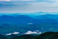
18. Goodnow Mountain (M) This hiking trail is located in Newcomb NY, approx 15 miles east of Long Lake. It boasts a Fire Tower and is a popular hike for families and day trippers. 1.9 miles one-way.

19. Adirondack Interpretive Center (E) Located in Newcomb 3.6 miles of wooded trails along Rich Lake. Family Friendly.

20. Santanoni Preserve (M) – Newcomb – 5 miles one-way. A wooded dirt-road traverses the wilderness leading to an incredible restored Great Camp of days gone by. This Great Camp complex at one time was a working Adirondack Farm. A great outing for the whole family.

21. Forked Lake Road (E) – 2.5 miles. Walk along a quiet wooded road leading to Forked Lake. Great road for walking in the fall and spring when traffic to the campsite is not as robust. Visit a lean-to site for views of the Raquette River and eventually arrive at the NYS DEC Forked Lake Campsite.

22. Buttermilk Falls (E) 0.2 miles. Most scenic waterfalls in the area. Heavily trafficked destination, but plenty of room for everyone. Short hike from the parking lot to the falls. Use caution after rainfall as there are many open rocks that makes navigation tricky. There is uneven ground and some steep rocky areas. Picnic area available. Canoe carry travels through this area.

23. Castle Rock (M) Blue Mountain Lake Trail. 1.4 miles one-way. Trailhead at end of Maplewood Lodge/Minnowbrook. Heavily trafficked trail. This trail can be hiked in and out and back or a loop. Amazing view is worth the trip.

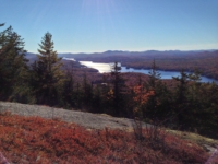
24. Blue Mountain (D) – 2 miles. Very steep. Expect rocky difficult rocky sections. Fire Tower. This trail provides an interesting day hike to the summit of beautiful Blue Mountain. the trailhead parking area is on the east side of Rte 28N/30, 10 miles from the Long Lake Town Hall at the crest of the hill.
The elevation is 3759 ft making it one of the higher mountains in the area. Communications equipment is located on the top of the mountain.
The sensational view at the summit is well worth the effort with vistas spreading before you which include the high peak area to the northeast. The trail is a tough walk, so be prepared!

25. Tirrell Pond (M) – Located in Blue Mountain Lake near Blue Mountain Trail Head or across from Durant Lake Campground.
3.5 miles one-way. Starts with moderate climb. There are connecting trails linking to Blue Mountain and Northville-Placid Trail. Hike this as a loop clocking in at 12.3 miles or out and back for a total of 8 miles. Overnight camping permitting. Fun place to swim.

26. Upper and Lower Sargent Pond (m) – From North Point Road/County Route 3 in Long Lake, NY. Upper Sargent Pond 1.2 miles one-way. Easy hike, great for families. Lower Sargent Pond has separate trail head 2.4 miles. Scenic ponds with lean-to’s and great fishing.
27. Lower Sargent Pond (MD) 1 Mile one-way. Trailhead access from a paddle down Marion River. This is a combo paddle hike.

28. Raquette Lake Railroad Bed (E) -2.7 Miles. Flat hike from the center of Raquette Lake along the old railroad bed. This is the raised bed of the old Raquette Lake Railway and it passes through bogs, swamps and along some scenic mountains. A wide variety of flora and fauna is visible along the path. The eastern trailhead is known as the Dillon Road. The western trailhead is opposite the eastern end of the Upper Pond on Browns Tract. There is a trail to Eighth Lake 0.5 miles from the western trailhead.

29. Death Brook Falls (E) – Raquette Lake. 0.2 miles one-way. Trailhead access across from the Golden Beach Campground off NYS-Route 28. Unique Brook and water fall. Also known as “Secret Falls” The best time to visit is the spring during the snow run-off or during times immediately following heavy rain.
It is a good place to see birds as the best path leads near a marsh along Death Brook.

30. Cascades/Powerhouse Trails (E) 1.5/1.6 miles one-way. Cascades Trail is on the western bank and Powerhouse Trail follows the eastern bank of the outlet stream from Sagamore Lake. There is no bridge across the inlet because, well there just isn’t. Pretty waterfalls, picnic spot. The Powerhouse Trail is part of the Great Camp Sagamore Historic Complex and showcases remnants of the former power plant that at one time powered the Great Camp for the Vanderbilt Family.

31. Sagamore Lake Loop (E) 3.7 Miles loop. Part of the Great Camp Sagamore Historic Complex. Sagamore Lake: A relatively level trail around Sagamore Lake. The trailhead is on Sagamore Road on the left, just before the outlet bridge and Sagamore Grounds.

32. Beaver Flow Loop Trail (M) 2.6 Miles loop. Wooded trail ends at Great Camp Sagamore Historic Complex. This is a moderately challenging route. This is a popular trail for cross-country skiing, hiking, and snowshoeing. The trail is open year-round and is beautiful to visit anytime. Dogs are welcome, but must be on a leash.

33. 7th Lake/8th Lake Loop/Old Uncas Road. (M) 7 Miles of a wood trail along an old historic logging road.
Extends 7.2 miles between two trailheads along State Route 28 – one across from the Seventh Lake Boat Launch and the other across from the Eighth Lake Campground. The Mohegan Lake Trail leaves the Old Uncas Road Trail 2.7 miles from the Eighth Lake Campground Trailhead.
Seventh Lake Mountain Trail extends 12.8 miles between the Limekiln Lake-Cedar River Road and the Sagamore Road. It connects with the Old Uncas Road Trail near each of the State Route 28 trailheads.

34. West Mountain (MD – D) 2.9 Miles to Summit. Moderate steep ascent with partial views of Raquette Lake. Foot trail access from Browns Tract Road will be cleared out and bridges slated for updating in 2022 to slog thru the beaver dams, boggy blowdown area (this is great news!) Ambitious can access the trail via boat via Sucker Brook Bay. Vertical rise of 1140 feet. Take Browns Tract Road for 0.7 miles from Raquette Lake road to reach the trailhead.

35. Browns Tract State Campsite (E) – Travel 0.2 miles to Sucker Brook Bay Trail. Options for hiking and exploring include the Sucker Brook Bay Trail or Shallow Lake Trail. The trail head to Sucker Bay Brook is located near the east end of the Upper Pond.

36. Cathedral Pines (E) – 0.1 miles from route 28. Ample parking available. Incredible stand of huge old growth pines. Visit memorial for a World War II soldier.

37. Ferd’s Bog (E) – 0.4 miles. Access this road off of Uncas Road linking Eagle Bay to Raquette Lake. Short hike to access incredible boggy marsh to view birds. Floating boardwalk, can sometimes sink in the water, so prepare for wet feet in times of high water.

38. Slim Pond (E) – 2 miles one-way. Located on Route 28. This is an out and back trail. Trail head located 1 mile east of the Golden Beach Campground.

39. Bug Lake/Mike Norris Trail (E) – 3.2 Miles. Bug Lake Trail extends from Uncas Road to the 8th Lake Campmgroun. Mike Norris Trail extends 2.5 miles between the But Lake Trail and Brown’s Tract Canoe Carry Trail.

40. Black Bear Mountain (D) – 2.6 Miles one-way from the Uncas Road Trail Head. Using this approach is a more moderate approach up the mountain. There is an alternate route and trail head parking lot in Inlet, NY off route 28. Expect mud water. More scrambles up the Inlet trail.


Blueberry Mountain
This trail can be accessed off of the Northville-Lake Placid Trail from Kelly’s Point. This is not an officially marked DEC Trail. Bring appropriate topo maps, gear, compass. It is a herd path as described below.
The ponds offer unparalleled views of the High Peaks. Boreas Ponds is reached Gulf Brook Road, off of the Blue Ridge Road, County 84. This area is about 25 minutes outside of Long Lake past Newcomb, heading towards North Hudson, and the Northway Exit 29.
An easy walk on a dirt road that passes a bog and wetland. At Lows Lake Dam you’ll find the remains of the Augustus Low complex. Near the damn is a new trail climbing a small mountain that clims a small mountain overlooking Lows Lake and Hitchens Pond.
Summit Rock and Indian Pass from Upper Works
Indian Pass is a historical significance for the Adirondack Park and was the key passageway to the discovery of the Tahawus Mine in the Upper Works Region.